
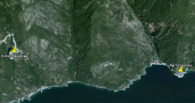
As you can see a thin grey line leads from Grigoriou upwards: this is a gravelroad, not drawn yet on the latest Zwerger-map (see below). Even on the Road Map Edition 2007 this road is missing.
But that did not mean the old footpath was totally lost, as happened on the other side of the Mountain, when the road van Karyes to Lavra was finshed. I was lucky to walk this magnificent path in 1980, when I visited the Holy Mountain for the first time. Sadly there are no traces of the path left ….

Sign that showes the old path to Simonospetras

Down below: Arsanas Simonospetras. Note the small hut on the right.

A dry well somewhere along the old path.

The small hut with rubber boat and mixer to make concrete. At this place the small brook ‘Chrendeli’ flows into the sea.

A large kellion along the valley of the brook. Here the path goes up again and a steep climb follows.

The writer of this blog rests on a primitive bench (photo self timer)

The well just above the arsanas of Simonospetras, with pilgrim Peter arriving. This spot is good example that the Zwerger-map is still the best there is for hikers, because the junction between the paths leading to both monasteries and the arsanas, is clearly shown on his 2004 map. The Road map just gives rough idea of how the paths lead.

The Agia Anna boat sailing to Dafni, seen from the well above Arsanas Simonospetras

And than, this overwhelming view of the monastery Simonospetras, on the ‘rock of Simon’.

A wooden door leading to the gardens of Simonospetras

The gardens of Simonospetras
Wim Voogd, 10/2/11
Thanks very much for pointing out Sotiris’ site – he’s done excellent work.
Are you aware of the Friends of Mount Athos footpaths project? Paths content of their website is currently being updated, but in the meantime here’s the link to the present version
http://abacus.bates.edu/~rallison/friends/footpaths/index.html
How long will it take to walk from Pantokrator to Gregoriou?
Very nice al those trails! Thanks Sotiris!
Estimation:
Pantokrator => Karyes = 1h30′
Karyes => Iron Cross besides big tree on the spineroad = 30′
Iron Cross => Simonopetra = 3h30′
Simonopetra => Agiou Grigoriou = 30′
Total = 6 hours
Guys, Sotiris already gave you the answer, 5,5 to 6 hours see here: http://vision.iti.gr/sotiris/routes/route.php?uid=1ac62a13 under ??????/Chronos = time (also thanks to Fremaki).
Hi all,
Thanks for your good words.
Just a notice. Walking durations are off-course always relative to the hikers abilities and load. The figures I mention are those that could be achieved by a relatively fit hiker (able to climb 400m per hour vertically and 5km per hour horizontally). So, allow plus-minus one-hour to those figures.
In case anyone’s interested, the Beylithou [ridge path] is now clear from Esphigmenou all the way via Hera to the main Karyes- Vatopedi road. Then it’s possible to walk down from this road to join the Karyes-Vatopedi footpath.
Links from the Beylithou down to Zographou, Hilandar, Konstamonitou and Vatopedi all currently in good condition.
Generally not all signal from the satellite gets through to your GPS, the signal scattering is usually from vegetation, sometimes from terrain, buildings, or other objects between you and GPS satellite.