
Before Christianity came to the peninsula of Athos the piece of land was called Akte. Very little is known about these small – unimportant – villages. In this blog I will show you some of the antique findings that are still to be seen in some of the monasteries.
In the context of Greek mythology Athos was the name of one of the Gigantes that challenged the Greek gods during the Gigantomachia. Athos threw a massive rock against Poseidon which fell in the Aegean sea and became the Athonite Peninsula. According to another version of the story, Poseidon used the mountain to bury the defeated giant.

Ancient cities on Athos with the names of monasteries – from Erich Feigl

Xiropotamou – gravestone from Apollonia “Thea ekali”

Xiropotamou – relief from Apollonia: the kidnapping of Marpessa, daugther of rivergod Evenos
Herodotus tells us that Pelasgians from the island of Lemnos populated the peninsula, then called Acte or Akte. (Herodotus, VII:22) Strabo reports of five cities on the peninsula: Dion (Dium), Cleonae (Kleonai), Thyssos (Thyssus), Olophyxos (Olophyxis), Acrothoi (Akrothooi), of which the last is near the summit of Athos. (Strabo, Geography, VII:33:1) Eretria also established colonies on Acte. Two other cities were established in the Classical period: Acanthus (Akanthos) and Sane. Some of these cities minted their own coins.

Vatopediou – part of a antique moument from Dion (Dium)

Vatopediou – a Bukranion animal sacrifice from Dion
The peninsula was on the invasion route of Xerxes I, who spent three years excavating a channel across the isthmus to allow the passage of his invasion fleet in 483 BC. After the death of Alexander the Great, the architect Dinocrates (Deinokrates), proposed to carve the entire mountain into a statue of Alexander.
The history of the peninsula during latter ages is shrouded by the lack of historical accounts. Archaeologists have not been able to determine the exact location of the cities reported by Strabo. It is believed that they must have been deserted when Athos’ new inhabitants, the monks, started arriving at some time before the 7th century AD.

Chilandariou – parts of the old monastery of Zygou (?) Zygou is NOT an ancient city, but a ruin near the Athos-border, formerly known as Frankokastro (see 584)

Arsanas Dochiariou – part of a Bukranion in a well
(all pictures from the book of Erich Feigl – Athos, Vorhoelle des Paradies, exept for the next one).
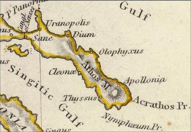
Map from 1829: Ancient Greece – London (note: some of the villages are situated in a different place than the Feigl map! Sane is the ancient name of Ouranopolis and Ouranopolis is on the wrong side of the peninsula).
Wim Voogd, 28/6
Interesting facts about the pre-christian antiquity of Athos, can be found at a publication issued back on 2006 by kedak.gr (centre for the preservation of athonite heritage), which was a heavily illustrated collective work consisting of several essays regarding that era of athos and the various remnants now scattered among the monasteries as well as the archaeological collections displayed in many of them. Most interesting essay of these was, in my oppinion, this of the archaeologists Papaggelos & Paliompeis who have done the official and extensive research on mt.Athos and presented a map with the thus-far-known places that actual ancient remnants/buildings have been found. The edition is unfortunately long out of print, but some copies might be available from second hand bookshops.
The cover: https://i.imgur.com/Dz2AUvI.jpg
and a page with a schematic map of the findings: https://i.imgur.com/iqTFg2J.jpg
The greek version of the above book has been recently released by athoslibrary in pdf.
https://athoslibrary.blogspot.com/2019/02/blog-post_19.html