
In the last blog from Herman you already saw a picture the kellion near Kaliagra.

I do not know if it is still inhabited, but it looks like it, because the roof and windows are intact. What is different from other settlements is the huge tower-like building that is attached to the living quarters. It looks rather old to me and I wonder what the purpose was of such a big square shaped building.
The name of the place is not mentioned in the Road Edition map (also look here).
Notice the structure at the end of the beach:
A former watertap / well at the beach, just below the building/kellion. Could the white marble stones originally come from antique Greek times?
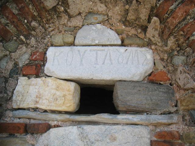
Obviously the place belongs to Koutloumousiou

When you continue the path to Stavronikita you will see this ruin of a building, that is almost destroyed.

Here in more detail (look here for a picture 20 years ago – thanks Dimitris)

Special formed bushes shaped by the wind protect you while walking

Pollution on the beach, even in this unspoiled place
And here the path from Stavronikita leaves to Iviron
Wim, 30/11
This cell is inhabited, as I have seen monks in there on many occasions. Iveron and Stavronikita are among my favorite monasteries so I often use this particular path. Probably Yannis from “Athos Memories” could fill you in regarding the name of the cell and its dependency. Regarding the trash on the beach in the photo, they are the result of the bad weather and the high waves that bring trash and wood trunks from all over the northern Aegean to this side of the peninsula. The almost destroyed building in the other photo, did saw some better days as the following photo proves:
http://www.trekearth.com/gallery/Europe/Greece/Macedonia/Agion_Oros/photo759769.htm
Maybe the name of the kellà is Agios Nikólaos Nerantzona, belonging to I.M. KoutloumousÃou, see map in: G.N. Pentzikis, Explorer 2003.