2271 – after 400 years: a (second) new building in Karyes

The latest image of the new Samaradiko from Voria.gr

The Greek website Voria.gr tells us that this new building in Karyes is the second(!) modern building in 400 years, called Samaradiko and that belongs to Lavra, and that it is almost ready to be used. The name is taken from the former building that stood on this site until the late 1970s or early 1980s. Although the Lavra monastery tried to reconstruct it, “due to the conditions, the lack of infrastructure for its restoration and the general difficulties, this was not possible”.

The new building on September 27th 2022, still under construction

Completely in harmony with the atmosphere of the city and the special space in which it is located, next to the Church of Portaton and the cemetery, a multifunctional building has been realized.

On the upper floors there will be a hotel with 24 triple rooms – primarily for employees -, a restaurant-café (opening mid-July 2023), a physiotherapy practice, a shop with church articles, an optician’s shop. The 500 square meter supermarket is expected to be operational in the autumn.

photo 27-9-2023 by Wim Voogd

The number of employees is constantly increasing, over 1,000, due to the many projects that are running this year moment in the Orchard of Panagia, but also of the pilgrims. It is worth noting that according to data, the number of visitors tends to exceed 150,000 per year, making the need for accommodation and hospitality areas imperative.

I personally am happy to see that a new hotel opens its door in Karyes, because my only hotel experience in 1986 was’nt that good (a minus three star-rating). I wonder what the small shops in town think about the opening of a large supermarket…..

Wim Voogd, 10-7-2023, source voria.gr (thanks to Japetus, Betinos and Vasilis)

Epilogue: Japetis informed us that you also can book a room in Karyes in a building that belongs to Esfigmenou (not from the old brotherhood), ask for father Joseph (+30 6951.970910 or email moytafi@gmail.com). This building is behind the new building of the Civil Governement.

You can also book the room through this website of Moytafi Travel:

“The cell Moytafi Mount Athos: For the gentlemen visitors we offer the choice to spend time in the Holy Mountain in our cell that belongs to the Monastery of Esfigmenos in the new brotherhood of St. John the Russian”.  

Posted in 01 Lavra, Karyes, news | Tagged , , , , | 8 Comments

2270 – a new discovery near Vatopedi monastery: an aqueduct!

In the morning of September 30th 2022 our FoMA footpath clearance team made an extraordinary discovery in the woods behind Vatopedi monastery. We followed the gravel road inland and first passed an apple orchard, where monks were busy harvesting:

FoMA signs near Vatopedi, the path to Konstamonitou and Docheiariou

Soon after we reached the orchard:

The orchard, full with plenty of apples to be harvested

We followed our way along the valley and the small, almost dried up stream, and arrived at the spot where we had to go up hill to clean the monopati.

clearing the paths with fallen trees
12.10 h Time for a break and lunch (with Bart, our teamleader)

If you walk a littlebit further along the valley and the stream, you will come to this new discovery, an aqueduct. I don’t think that this place has ever been published on the internet (or anywhere else) before!

The new discovery: the Vatopedi aqueduct
The aqueduct: the right side, also with three smaller arches
The main arch of the aqueduct, seen from the other side
The view from above: the aqueduct is almost completely hidden by trees and bushes
the brook with clear water
Probably a brown frog
The Vatopedi aqueduct video

Wim Voogd, 21 June 2023

Posted in 02 Vatopedi, nature, Trip 2022 | Tagged , , , , , | 1 Comment

2269 – FoMA footpath team 2022 – part 3.02: the Ridge path above Vatopedi to Chera

In the second part of our clearing day on September 28th 2022 we made a classical mistake that often happens when hiking on Athos, by paying no attention while walking on a dirt road and missing a sign in the bushes.

In the last post of this hike, I explained how we almost got back to the starting point of the monopati we walked (part of the original Ridge trail), because an avalanche and fallen trees blocked our way. But one of our team members managed to find a way through it: shortly after, we met Father Nifon, who helped us get back on track. So we continued our journey north on the dirt road (which road is now part of the Way of the Bay/the Ridge path).

A few hundred meters further on we had to look for the beginning of a monopati, to resume our clearing task. At the fork we had to turn right and came out on a newly dug dirt road. And it is here that we made our mistake by missing the turn to the left, where the path continued in the forest.

The wrong way: newly dug dirt road

Soon we realized we had missed a turn as we saw a monster bulldozer destroying Athos and we realized that this newly dug road could never be part of the old Ridge trail. Bart asked the driver if he could help us: we had to walk back to find the right turn!

The bulldozer on the new dirt road

And finally we found the right turn, at the beginning of the newly dug dirt road, even with FoMA signs. How could we missed it? We continued our way.

A good example of why it is nescessary to clean the paths on Athos: a thick fallen tree lies over the path.

This is where the Way of the Bay meets the monopati that goes down to Konstamonitou, as shown with a yellow arrow on the Howorth map below:

Detail of the Peter Howorth map, buy it here.
14.20 PM: time for a pauze

Only few hundred meters away from the famous Chera point: an old house or farm in ruins, with a wheel to be able to get the water from the (dried) well.

And then we finally reached at 15 PM the famous resting place and well, Chera, or The Hand:

Chera, seen from three angles
A haute-relief with faded inscriptions from 1851 and with a hand pointing to the south and in the direction of Karyes.
The text above the wooden cross (Slavonic text?)
The second hand pointing to the north and Sografou.
with a picknick table and signs everywhere, see pictures below

From Chera it was a relatively quick hike downhill back to Vatopedi.

An old dried well on our way down
15.45 PM: Walking through the gardens and olive orchard of Vatopedi

This ends our 9 hour working day and efforts to clear the paths near Vatopedi.

Wim Voogd, 5-6-2023

Posted in 02 Vatopedi, nature, Trip 2022, walking | Tagged , , , | Leave a comment

2268 – FoMA footpath team 2022 – part 3.01: the Ridge path above Vatopedi to Chera

At 6 o’clock we woke up for our next day of cleaning the Mount Athos footpaths: breakfast was served at 6.30, with delicious calamaris, potatoes. olives and a glass of rosé wine.

Our crew at the breakfast table. the other pilgrims were still in church

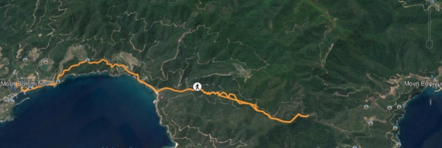
Our aim for this day was to clear the paths that are part of the so-called Ridge path or the Way of the Bay. On the map below from Google Earth you can see the entire route we cleared:

But first let’s take a closer look at the first part, which ended in a little adventure.

7.20 PM First we passed the Vatopedi checkpoint, which, as you can see, we were allowed to pass.
7.40 AM: sunrise near the drop-off point, with Thasos on the horizon
The drop-off point with an iron cross on a concrete base
At the beginning of the path we thought we should clear, Tsjeu started cutting down the first tree.
This old sign says: Apo monopati IM Docheiariou, IM Konstamonitou and IM Sografou.

There was also an official FoMA sign at the beginning of this path. At that time we did not have a clue what would happen later and that we should have followed the dirt road ….

At first, 90% of the trail was easy to walk, but later it became more and more difficult, with fallen trees blocking the way

A sign that belongs to FoMA has grown into a tree, probably a long time ago…….
At a certain point we passed this waterless stone spring, dating from 1890
I could read the words DIM Konst(amonitou?) and Liariko(?) Xarx.dox and … / ….1890
Then we passed this huge dead tree. When we looked closer, it looked like someone had once lived there, because we saw corrugated iron that may have served as a roof?
Maybe a place where a hermit once lived?

Shortly after we passed this big tree, we got into real trouble, because the trail completely disappeared from view. You could tell that years ago the forest was crushed by an avalanche that wiped out the trail. Trees were scattered all over the area and they were overgrown with weeds and vines, it was almost impossible to move on. Every member of our team struggled to find a way, shouting to each other through the forest to hear an update on their efforts. It was almost impenetrable even with our loppers, until Lukas (the young man in the photo above) finally managed to find his way through. He kind of saved us, so we shouldn’t have to walk all the way back.

Shortly after we made the climb out of the avalanche area, we were welcomed by Father Nifon, who has a cell with his brother nearby. He had heard us calling to each other and he yelled back, but we didn’t hear him (and couldn’t reach him anyway). He told us that every now and then pilgrims take this path by accident and come out bruised and sometimes injured, happy to finally meet someone. He said it would be best to close the trail until the trees in the avalanche area are completely cleared. We did indeed close the trail on our last day on the way back to Dafni. But the path is beautiful and it would be good if it could be used again at some point in the future (the alternative is a boring walk on a gravel road).

The cell of Father Nifon
the vegetable garden of Father Nifon
Bart and father Nifon view the map before departure

Wim Voogd, 5/6

Posted in Trip 2022, walking | Tagged , , | Leave a comment

2267 – a drone footage of Mylopotamos winery

In this post we proudly present yet another unique footage, shot by monk T on May 5th 2021 during the Corona pandemic, when no one was allowed to enter the Holy Mountain. This video shows you the winery of Mylopotamos, owned by Lavra monastery, where the late father Epifanios, monk, winemaker en cook, prepared his delicious and mostly vegetarian Athos meals. Read this post to learn more about the wines and more about our 2009 visit to this place.

A litlle further is the arsanas/harbor of Filotheou monastery and the chapel of the Panaghia Glykophiloúsas, which we wrote about in post 1892 after a visit in 2015.

Wim Voogd, 24th of May 2023

A little further on is the arsanas/gate of the Filotheou Monastery and the chapel of the Panaghia Glykophiloúsas, which we wrote about in post 1892 after a visit in 2015.

Wim Voogd, 24 May 2023

(Notice for our readers: due to technical issues with our WordPress host and an (expensive) upgrade that has to be done, we haven’t been able to publish many posts lately: we apologize for that, hopefully we’ll be back soon with new photo content).

Posted in 01 Lavra, 12 Filotheou, films, Mylopotamos | Tagged , , , | Leave a comment

2266 – more Athos maps

A map from 1585 Abraham Ortelius, a Brabantian cartographer from Antwerp, with antique Greek names of villages on Athos

1650 Alexander à Via Venice engraving folding map Athos, with texts in Greek, Latin and Cyrillic

Detail of the left top corner with a text in Latin and a drawing of Christ on a throne with Maria and Johannis.

Detail of the sea with different (Venetian) boats and small rowboats with monks and whales or fish

Detail with a brook streaming down the Athos mountain and with Lavra and Iviron (with the -burning- Portatissa icon emerging from the sea). Look at all the towers firing canons!

Detail nr 4: the monasteries on the West coast of Athos

1727 Athos map with antique cities, with a text in French: Carte de Thrace pour servir à l’intelligence de l’histoire romaine par Henri Liébaux, géographe

1840 Russian Athos map with images of Athos

1857 German map: Karte vom Berge Athos

1875 English map of Athos

1882 English map of Athos

1899 Austrian army map

1903 Greek map

1940 French map, you can have a detailed look of this here or http://www.cartomundi.fr/site/E01.aspx?FC=91026

1944 German map, Karte from the book “Mönchsland Athos 1941” by Dölger

1974 Greek map

2009 – photo from an (older) Greek Athos map, found in monastery Grigoriou

date unknown: modern Athos map by lectus.gr

date unknown: Greek Athos map

date unknown: old engraving, French Athos map

date unknown: Russian Athos map. Here a road or path leads to the Holy Mountain (?)

2023 – the Peter Howorth Athos map: the maps are ‘print on demand’. This means that there will be constant refining of the maps for the immediate future. The best and most up-to-date map there is, available here.

Wim Voogd, 11-5

Posted in maps | Tagged , , | 4 Comments

2265 – a drone footage of a Pristine Territory of the Holy Mountain: the Réma Dontá cataracts

Drone flight along the waterfall of Dontas stream, near the Dontas winery of Simonospetras / 18-12-2020 by monk T

The Holy Mountain was founded in 963 with the construction of the Great Lavra Monastery by Saint Athanasios. Soon after, the rules of the Avaton were imposed: women were not allowed to enter this part of the world. After this, 19 more monasteries were built in this remote, mountainous and sparsely populated area of the Byzantine Empire. In its heyday, perhaps a few thousand monks and laymen lived on the Holy Mountain, in less fortunate times there may be only a few hundred monks left. As I walked the beautiful trails of the peninsula, I often wondered if there could be an area of this remote and almost uninhabited part of the world, where no human has ever been. When I first saw monk T’s drone footage of the Réma Dontá Valley, I was pretty sure this was the place I was looking for.

A detail of Athos map of Peter Howorth with the dead end road and the Réma Dontá valley

The place is not far from Dafni, but if you want to visit the Dontas winery, which is at the beginning of this valley, you have to leave the road that leads to Simonospetras and take a dead end road, so not many pilgrims (or monks) go there. And looking at the rocks and waterfalls in the Réma Dontá Valley, I think my idea that no one has ever been to this part of the world, could be true. Thanks to monk T’s drone footage, we now have the opportunity to see this pristine territory of the Holy Mountain!

The drone flight along Dontas valley / 18-12-2020 by Monk T: ©
Dontas valley 18-12-2020: a small pool: photo by monk T.

I hope to visit the Dontas winery this year after being part of the FoMA footpath team eand during my 14th Athos pilgrimage.

Wim Voogd, 17-4-2023

Posted in 13 Simonos Petras, nature | Tagged , | Leave a comment

2264 – a drone footage of skiti Panteleimonos and the cell of Ag. Paisios

The cell of Ag. Paisios next to the valley of Koutloumousiou 02-08-2020 – photo by monk T.

This latest footage of monk T., already made in 2020, shows us unique images of rarely visited skiti of Ag. Panteleimonos (also called skiti Koutloumousiou) and of the famous and often visited the cell of Saint Paisios, that lies closeby on the other side of the valley, near the monopati that leads to Iviron.

The drone footage made by monk T on August 2nd 2020

The area that the drone flew over, Google maps, source https://agionorosroutes.blogspot.com/. The yellow line is the path from Karyes/Koutloumousiou to Iviron.
A cell at the edge of skiti Panteleimonos and the Panagouda cell of Saint Paisios in the background, 02-08- 2020 / photo by monk T.
The tiny bell tower of skiti Panteleimonos and the cell of Ag. Ioannis Prodromos

This skiti is rarely visited by pilgrims, because most hikers take the monopati that lies on the other side of the valley and that leads to Iviron, and of course, the famous cell of Saint Paisios, with the characteristic chairs in the garden, made of felled trees. This place would be another target for a next visit to the Holy Mountain!

Skiti Panteleimonos on Google maps, source https://agionorosroutes.blogspot.com/

For pilgrims who have plans to go to Athos, please have a look at our reservation post nr 1835, because there have been some updates with new information.

Wim. Voogd, 21/3/2023

Posted in 06 Koutloumousiou, skiti | Tagged , , , , , , | Leave a comment

2263 – FoMA footpath team 2022 – part 2: the path from Vatopedi towards Esfigmenou

a part of the route:: the paths we cleared on 26th of September

On Monday, September 26, 2022, our team started our first mission, clearing the path between Vatopedi and Esfigmenou. After waking up at 6am and having breakfast at 6.30am specially made for our team, we got a lift from a grumpy Greek driver, who couldn’t understand why we had to go up the hill, thinking we had can start working on the trails from below, near the monastery (it would have taken us an hour to walk up the hill to our starting point!). Anyway, we finally reached our spot to start our day cutting down and removing obstacles such as bushes and trees, to ensure that pilgrims can have a good and safe walk on the Athos hiking trails.

But before I continue describing the work on our first day, I would like to share a webinar where two of our prominent members of the FoMA footpath team attended, Chris Thomas and Peter Desmond, which took place in February 2022. In this video of a webinar from the Anglo-Hellenic League, viewable on YouTube, the story of the FoMA footpath team is told. What I didn’t know was that (at the time) Prince Charles played an active role in the foundation of the footpath team in 2004, 18 years ago. He asked the members of FoMA to set up a team of footpath cleaners to preserve and maintain the Athos trails. He even helped a team in 2004, as you can see in the photos below, which I ‘took’ from the video.

The FoMA footpath team: Chris Thomas and Peter Desmond

Prince Charles joining the FoMA footpath team in 2004

Father Mathew from Vatopedi discribed our mission as follows in simple words: “make shure that a monk on a donkey can pass the paths smoothly”. With that simple task in mind we put on our work gloves and took our loppers and saws and started working.

2022: a kalderimi with cobblestones

Most kalderimi, these are the wider paths that have been paved with cobblestones in the passed centuries, do require much work, although sometimes you have to remove fallen trees or the most annoying plants, the broom plants with their vicious thorns – see photo below.

Cytisus lanigerus – broom
working at a path near a the FoMA sign to Chilandariou / Esfigmenou
10 o’clock: a break with the famous coffee of Bart Janssens, our team leader
the Greek airforce flying over the peninsula
A view over the Vatopedi bay, with Mount Athos in the background
panorama photo of this area
12:50 pm Here we are half way through our mission, at the place where the monopati stopped in the forest and where bare rocks appears on the path that leads further down to Esfigmenou (with a broken sign on the ground to Vatopedi!).
The team on our way down to Vatopedi: Lucas, Daniel, Justin and Bart
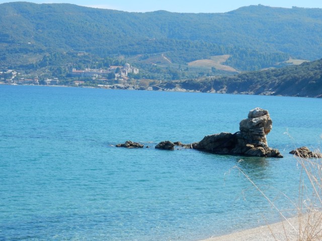
back at the coast near Vatopedi: doesn’t the rock in the sea look like a sfinx?
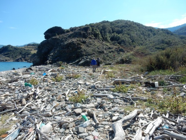
the path continues along the coast: I learned from the webinar as mentioned above that special teams of Greek volunteers try to focus only on cleaning the beaches and removing the plastic. This beach has not been visited yet….. At 3.30 pm we were back at the monastery, after a walk of almost 13 km

Unfortunately the old trapeza of Vatopedi is being renovated while we were there, so dinner was served at 5:30 pm in a cellar near the kitchen: that night we got spaghetti with tomato sauce without oil, but with olives and fruit (not wine but fruit juice) . Let’s not forget to mention Father Mathew’s hot sauce made from the Carolina Reaper pepper, the hottest pepper in the world: just 5 drops of it in my spaghetti and it almost killed me too!

In the middle: the Carolina Raeper sauce of father Mathew

Wim Voogd, 14-3-2023

Posted in 02 Vatopedi, food, Trip 2022, walking | Tagged , , , , , | Leave a comment

2262 – a drone footage of three towers of Mount Athos

Video made by Monk T on 5th of March/May 2021

This footage is made by monk T and shows three towers of the Holy Mountain: the first one is Palaiopyrgos, the ruins of an old tower between the arsanas of Sografou and Konstamonitou, for more information read this post on our weblog: 2221. The second tower is the one of Karakallou on the East coast. also see post 2127. And the last tower is the Amalfi tower, near Morfonou beach, a remnant of an old Katholic monastery, that once stood on this spot (before 1054?).

For more infomation about the towers on Athos I can recommand this book: The Towers of Mount Athos from 2001 and this collecters item with woodprints from all towers.

Wim Voogd, 7-3-2023

Posted in 11 Karakallou, arsanas | Tagged , , | 1 Comment